February 17-18, 2002
why did the donkey leave, about rocky racing, and a coiled dragon
| Following tracks of the Lost Burro (2/2) February 17-18, 2002 why did the donkey leave, about rocky racing, and a coiled dragon |
And so we were rolling down the donkey trail from Quackenbush; I don't know what Sid was doing (I honestly hope he was driving), for I had my eyes closed, teeth clenched (and my butt tightened up). Sid claims I was looking pale green, but I doubt that he managed to watch the color of my face and the road at the same time.
 |
||
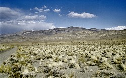
| Hidden Valley offers, besides a million of thorny bushes, and temperature near freezing, also a view to laterally striped hills |
In no time we really reconnected to a bulldozed road from which our GPS had diverted us before so aimlessly. We dutifully damned creators of the map (for a second time already) and continued on Ulida Flat and through beautiful Hidden Valley. A frequented yet not too well maintained dirt road always infallibly transforms into a "washboard" - hard ripples from one side to another, in the exact distance (about 4 inches) to shake your soul out of your body at any traveling speed. Hence we wailed and so did our Wagon. Then, Lost Burro Gap opened in front of us - I must say that if the poor donkey had to endure the same journey as we did, no wonder he had enough and hit the road. The gap is special in that a road and a river (now dry) must share the same space. Well -- that means a dry river bed becomes the road, with all you would normally find in a river bed - huge boulders, big gaping holes, undercut banks... we nervously counted remaining miles to Teakettle Junction.
 |
||
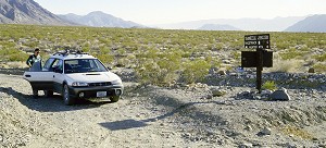
| Teakettle Junction - no big hit, but one can at least expect a sign of civilization in the form of a park ranger passing by |
Not that Teakettle Junction would be anything extraordinary -- an intersection of three washboard-like, rocky roads, marked by a post with signs, with real tea kettles attached to them. Our Hunter Valley Road and Racetrack Valley Road met there with a connection to Death Valley, we hoped that this spot would be somewhat more often visited than the wasteland we had driven through so far. There was hardly any sign of improvement of the road quality, but a moving dust cloud on the horizon announced that we could possibly ask for help here in a case of an accident, for example.
We had six more miles remaining to Racetrack - the dust cloud on our horizon settled down and when we drove up to it, we found a park ranger helping to repair a tire of a disabled SUV. First parking lot at Racetrack Playa contained a couple of strangers, apparently a part of the group belonging to the aforementioned SUV, who walked those six miles to see this natural wonder still during daylight. They seemed to incline towards begging us to drive them out of there, but they had no chance with us -- we wanted to see everything first, now that we sacrificed so much time and effort.
 |
||
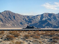
| Grandstand maybe it is not located in the middle of the "racing track", but we're not picky |
A playa is a lake bed. In this case, it is made of clay, dry most of the time (let us not forget
we are just a stone's throw away from Death Valley -- a place with least precipitation on Earth),
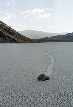
and cracked up into many small "tiles". Vagabond boulders are scattered on the surface
- perhaps brought here by water - some weigh up to six hundred pounds, but most about the size of
a human head. These boulders keep "racing" on the absolutely flat surface of the playa
-- apparently in the times when in rains a little or temperature drops below freezing, the clay playa
surface becomes super-slippery, so that wind can push the rocks around. The boulders leave a track
behind them in the mud, which eventually dries down and becomes concrete hard, until the next wet season.
More information and interesting pictures can be found on official pages of
US Geological Survey,
though you may believe that somebody (UFOs, or geologists themselves) move the rocks and then
secretly laugh at all those enthusiastic photographers. Frankly -- no one ever saw the secretive
boulders move, so who knows, how it really happens...?
 |
||
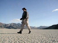
| Hippo at Racetrack Playa the racing surface is flat, windswept clean, and beautiful |
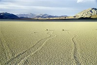
We walked around Grandstand first, which sticks out in the middle of the "racing track". We stepped on perfectly matching "tiles", beautifully swept by a cold wind. When did you walk last time on a perfectly horizontal, huge natural plain? 3,708 feet above sea level elevation means, even here in the desert, mostly cold weather -- we had to return for some wooly hat and fleece, and to read our guide papers again -- vagabond boulders are concentrated at the southern end -- and the sun began to set, while the end of the playa disappeared in the distance -- we jumped into the Wagon (those two desperados already left) and drove a little. Again, we were rewarded for our late arrival -- only two photographers remained on the plain, who thoughtfully avoided casting shadows within our camera's viewing angle, and sent us to the most picturesque boulders. By the way, they, too were from Palo Alto. And so we shot one picture after another, until our fingers were all tender because of frost...
 |
||
| Racing rocks |
Once the sun had set, it was clear we could not return over the same road to Lone Pine (to travel again through fifty miles through the Lost Burro and undercut zigzags at night did not strike us as a good idea), but we still had to cover about half of the distance, driving on a washboard dirt road to a paved connection leading to Death Valley. If cellulite can be really prevented by a thorough massage of one's fatty tissues, then I'm definitely prevented from contracting this ailment any time soon. My butt still prickled when we were driving through Stovepipe Wells and our Wagon's shocks never stopped squeaking since then.
Our adventure had a tiring effect on me - and so Sid drove through the night at Death Valley, listening to my snoring. I returned behind the wheel back on Highway 395 and covered an hour or two, until I started seeing double, approaching Tehachapi pass -- Sid had to take over for few last miles of winding freeway, before we settled down at a proven Travelodge. There we discovered that if my digital camera batteries give up in the middle of writing an image onto a memory card (which happened because of swapping batteries between the camera and our GPS in the wasteland), image directory gets corrupted and all images are lost (if you're interested, Sid eventually hacked them out of it as one huge data file that he had to parse into individual jpg's).
 |
||
| A Racing Rock - lonely runner |
Morning found us in merrier spirits -- suddenly we did not feel like going home yet, and some "art" murals in the hotel's lobby reminded me of the fact that I never saw the famous Tehachapi Loop on my own eyes. The name itself is said to come from the Indian Kawaiisu language and means "steep climb". There are several alternative expressions, and the spelling was changed so many times that anybody can hardly tell today what it might be. Steep climb is somewhat logical (quite better than alternative of "much water and acorns", or "plain grown over with oaks", or "windy place"). This pass at 4,000 feet altitude became an engineering challenge of late years of the nineteenth century.
 |
||
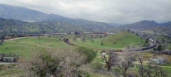
| Tehachapi Loop a curled dragon - its end just came out of a tunnel, while the front engine is one full circle ahead |
Southern Pacific Railroad decided to connect its networks in central California with the South -- namely San Francisco with Los Angeles -- across the mountain ridge at Tehachapi. Well -- from Bakersfield to Caliente it was merely a routine job, but the altitude gain from Caliente to the pass was 2,735 feet. Highest allowed slope for trains was 2.2%. Engineers eventually came up with an unorthodox solution, how to "climb" seventy seven feet near Keene -- the train would go through a tunnel, then loop around 360° and gain elevation in one spot. The loop is 3,799 feet long, with the average diameter of 1,210 feet. With today's long trains it is not uncommon that the front engine goes over the tail cars of the same train.
Construction work was provided, as was then customary, mostly by Chinese workers from Canton. The whole line between Bakersfield and Mojave was opened on July 10, 1876, has 18 tunnels and its turns all added up amount to 8,700 degrees. Work was done with help of dynamite -- and then only picks and shovels. Tehachapi was called Walong by the Chinese. And there again exist at least two expert translations - it either means Chinese Way or Coiled Dragon. I would personally side with the dragon, for long trains curling through the mountains look very impressive.
 |
||
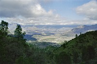
| Isabella (town and lake) |
Finding Tehachapi Loop is not difficult -- arrows will lead you from highway 58 all the way to a monument sign. Which is nice, but you can't see much from it -- one must run up the nearest hill and suddenly you feel like the father who finally managed to give his son an electric train for Christmas. About forty trains pass through the loop daily, so the probability to see a fully loaded freight train with extra engines, as it "chases its own tail", is quite great. And it is a delightful sight. If only it was not so cold out there, we would be standing on that hill perhaps to this day and succumb to a real Trainspotting Passion.
The train disappeared in the hills and we still did not feel like going home -- and so we picked another detour over Fig Orchard and through Walker Basin almost all the way to Lake Isabella, and then along Kern River to Bakersfield -- we drove through the canyon of this wild stream several times already, but always at night -- so this time, I could finally enjoy the view. It's a rafting paradise, and we've got some time till summer to think about it.
| Copyright © 2002-2005 by Carol & Sid Paral. All rights reserved. |