September 1 - 9, 2001
to the north and to the south of us.
| Shortly Tripping September 1 - 9, 2001 to the north and to the south of us. |
 |
||
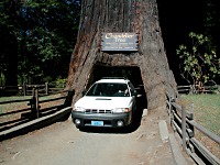
| Not all the trees in California are being hugged by naturalist lunatics. Some had been modified to be driven through with a car -- for a fee -- while the tree keeps growing happily. |
 |
||
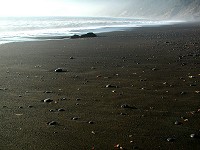
| The Lost Coast was named more in the sense of "forlorn" than "misplaced". There are really only a handful of people, but lots of black volcanic sand. |
We were blessed by yet another three-day weekend. Just like anywhere else in the world, Labor Day is celebrated here by not working. Plans began to emerge in our minds, about going north and explore parts of Lost Coast and redwoods, perhaps to raft down some river. However...
... we got befallen by laziness -- and taxes. During Spring, we had to apply for an extension, as taxes are done here on a computer and submitted over the net. Our program refused to communicate, as I had no social security number. We applied for a special replacement number just for the purpose of tax return. That one never came, though in May I got a working permit and with it a privilege to have a SSN. Would you expect us to sit down right away in May and submit our tax return then? No way, there was plenty of time till August 15, so we put it off again and again -- until it was September. We had no other choice but to trim down our three-day plans, substituting for taxes on Saturday and only then leaving.
Saturday night did not find us in a good mood for leaving - Sunday morning seemed better.
Since only a nut would plan his return on Monday (holiday) evening, during an all-reaching traffic jam, our trip
shrunk to one that would take a mere afternoon -- were it not 300 miles away. .
.
Our first stop was at a drive-through redwood tree. You pay three dollars at the entrance and proceed through a beautiful forest to a small plaza with the said attraction. You can drive through the tree as many times as you like, which most of the tourists do -- first shooting a picture with Mom behind the wheel, then Daddy drives, then Grandma, then Grandpa, plus permutations of children hanging around -- you can imagine that during a high season, there's quite a line. The tree itself is about 300 feet tall, ground diameter is about 20 feet, and is believed to be 2,400 years old. A tunnel through the base was cut probably before nature protectors outgrew their diapers. Most interesting seems to be the fact that the tree survived such a violent intrusion, as well as never ending crowds, and grows on happily.
 |
||
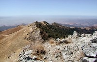
| Fremont Peak Ridge |
 |
||
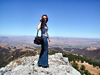
| Líba is shooting a video of our view from Fremont Peak |
Our second stop was on the coast -- Sid claimed that it would look just like the coast where we live,
but completely different.  .
His contradiction proved to be correct. Rocks, beach, ocean, boulders -- all that I saw before.
However, Black Sand Beach is made of -- black sand.
For some reason it does not look gloomy at all. You notice its surroundings much more intensely, you realize
it HAS colors -- a blue ocean, green trees, colourful pebbles on the beach. Black Sand Beach goes on for many miles,
and I noticed that it is a favorite destination for many wanderers. Load a backpack and a tent, and you can go wherever
your feet will carry you, and you can live there. It's obviously easy to find a deserted piece of sand for camping
(I mean at least half a mile of empty beach in each direction).
We hiked on the beach for just a while -- only an hour and half, waited there for the sun to set, and returned while the night fell on us, to our Wagon. We were to drive five hours to get back home. If you think now that it sounds abnormal (to drive ten hours to walk a beach for three hours), you can be sure we think so, too. But we agreed that we really love to drive together -- listening to music and funny theater pieces (Cimrman), we talk, take turns behind the wheel -- simply fun.
During our trip, our car kept rattling, worse and worse, but only while it was going downhill. I had planned another trip with Líba on Wednesday, so I had to harass Tony and make him fix it somehow.
 |
||
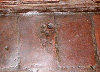
| Animals used to walk undisturbed over drying clay tiles for the mission floor. |
Naturally while Tony sat in the car, no rattling came. I had to resort to describing it vividly. Eventually we figured that all the racket came from a metal cover around a drive-shaft, the same one we had to straighten at Stanislaus NF manually. We probably missed some tighter spot or bulge from a flying rock. Repair was a matter of minutes and I could drive away on my next trip.
 |
||
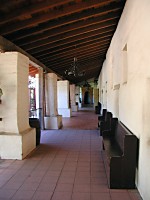
| The arcade of a mission is a pleasant sanctuary from the heat of the day |
My plan with Líba was to visit Carmel and return over Highway 1, but local experts urged to advice. Martina added a Spanish mission in San Juan Bautista, and Sid suggested Fremont Peak. I was never to either place, and eagerly included them in my programme.
San Juan Bautista Mission was founded on June 24, 1797, by the President of California Missions, a follower of a famous Franciscan monk, Junipero Serra. It was the fifteenth mission out of twenty one in Alta California (upper California). In July 1803 was laid the cornerstone to a largest mission church building. Interior was finished in 1817 by completing altar work and laying down tile floors. I find the church very pretty; a European who is used to graceful yet cold cathedrals, will certainly be pleasantly surprised by warmth inside -- the building is mostly wooden and insulates well. Another (quite funny) dimension is added by the above mentioned tiling -- the tiles are made of sundried clay -- and full of imprints of animal paws. Some are only featureless depressions today, but others keep their characteristic shape after two hundred years. A side door exhibits another device, quite unusual for a cathedral -- a cat flap. After first harvests the missions found their fiercest enemy in mice; monks defended themselves by allowing cats to roam freely through all places. These little details give the whole mission a cute touch of common household. Add shady arcades, a breathtaking garden, a humble cemetery, and you get a quiet sanctuary where even time seems to slow down.
 |
||
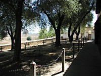
| A humble mission cemetery is located near San Andreas fault |
But beware the illusion of tranquility -- San Andreas Fault runs right at the foot of a hill that holds the cemetery. A strong earthquake of 1906 damaged the church walls, and they were not repaired until 1976.
Not far from the tiny town of San Juan Bautista, which looks more like a historical monument of the old America, stands Fremont Peak. General John C. Fremont raised here the first American flag on California soil on March 4, 1846. At least so says a plaque mounted at the top. My humble research discovered that Mr. Fremont was only a captain in 1846, a military explorer and surveyor, whom president James K. Polk sent to an expedition to Oregon and California, and should there be an outbreak of war in California, he was to attempt to negotiate peace. At the time, shortly after separation of Mexico from Spain, situation in California was rather unclear. Both the Church and Spanish state claimed ownership of the land, a new Mexican government in turn wanted to use it as reward for its celebrity independence fighters; England even sent a ship with settlers to the West Coast (who eventually sailed back due to this instable political situation). Over Sierra Nevada mountain range, American settlers poured in -- partly trying to fulfill the "Manifest Destiny" - theory that United States should reach from coast to coast, and partly motivated by legends about California gold. Those, of course, would not care less for clerical, Mexican, Spanish or English rule; they wanted California added to United States (in which they succeeded at the turn of 1846/47).
 |
||
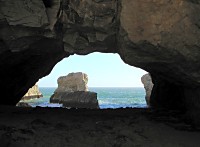
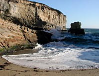
| One can pass through this cave and reach a miniature beach. |
Getting back to Fremont Peak - whatever was the true history of the flag, the place was a damned good one. You can see far out for many tens of miles, in all directions -- towards Monterey Bay, and into Salinas Valley.
 |
||
| Strong surf tends to chase you right back to the mouth of the cave |
With our ascent, we have "passed" all points planned for us by Martina and Sid, and still there was our original route to go. Líba decided that one mission was not enough and demanded to see Mission San Carlos Borromeo in Carmel. We rushed through and out to Carmel down town for lunch. Unfortunately, it was already half past three and it took us a while to find a restaurant to still serve lunch (or already serve early dinner). Líba said she never had Mexican food, and so we got tasty burritos.
Returning over Highway 1 - a famous route along Pacific Coast -- took somewhat longer than driving on a freeway (and there was the usual jam around Santa Cruz), but I found again a tiny beach with a walk-through cave, which we already admired with Sid the other day.
At San Gregorio Beach, we still had some 30 miles to reach the Skyline ridge and Borel Hill, yet sun began to set already. We missed the view from the top by just a few minutes, but still, Líba could see the whole Silicon Valley. I would like to use this opportunity to virtually decorate her with a medal for general bravery, for she lasted through my driving in those infamous switchbacks without losing even a bit of a burrito.
| Copyright © 2001-2005 by Carol & Sid Paral. All rights reserved. |